

General
Mt Kilimanjaro is a giant strato-volcano that began forming 2.5 million years ago when lava spilled from the Rift Valley. This is the highest freestanding mountain in the world and 1 of the 7 Summits as it is the highest point on the African continent. Mt Kilimanjaro is a large massif that is comprised of 3 volcanic cones: Kibo (5895m – dormant); Mawenzi (5149m – extinct) and Shira (3962m – extinct). Mt Kibo last erupted 360,000 years ago while the most recent activity was recorded around 200 years ago.
Although Mt Kibo is dormant, Kibo has fumaroles that emit gas in the crater. Scientists conclude that molten lava exists around 400m below the summit crater. Several collapses and landslides have occurred on Kibo in the past, one of these landslides creating the the area known as the Western Breach.
Mt Kilimanjaro is unique in that during the ascent, hikers climb through all climatological zones. Starting in the Tropical Rainforest through the Heather/Moorland and the Alpine Desert to the Arctic zone on the summit.
Mt Kilimanjaro boasts many hiking routes to reach Kibo’s summit (Uhuru Peak). 6 major forest/moorland routes that reach this around-the-mountain trail system and 3 hike/scramble routes that ascend to the summit of Kibo.
The 5 forest/moorland ascent routes (clockwise with 12 o’clock = North) are:
Rongai & Loitokitok
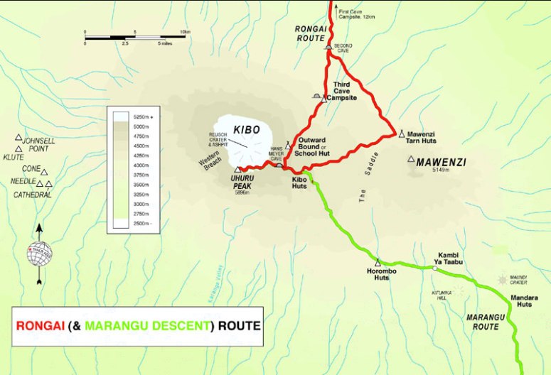 Marangu

Umbwe

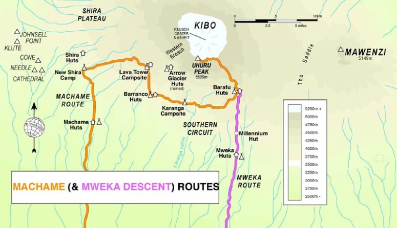
Machame
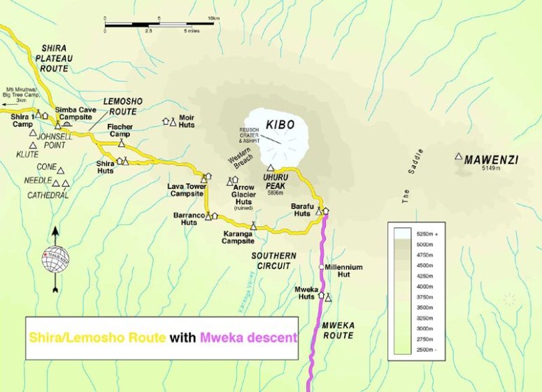
Shira & Lemosho/Londorossi
The 3 summit routes are:
- Normal (Class 1-2 extension of Marangu)
- Barafu (Class 2 extension of Mweka)
- Western Breach (Class 3 extension of Shira)
The Rongai, Umbwe, Machame and Shira routes are ascent routes only.
Hikers on Rongai and Marangu descend via Marangu
Hikers on Umbwe, Machame and Shira descend via Mweka.
Mweka is a route for descending only.
There is an alternate Shira/Lemosho route that traverses the mountain from the western edge (Moir Hut) via the northern slopes where it meets up with the Rongai route before ascending via Gillman’s Peak (see map – Northern Circuit marked in grey). It is not widely publicised due to a lack of extraction facilities on the Northern Circuit. If you want peace and quiet though, this is the one to go with.

Ascent to Uhuru Peak
One reaches the Reusch Crater rim on Kibo through 3 points.
- Gilman’s Peak 5681m on the Marangu route
- Stella Point 5739m on the Mweka Route
- Western Breach 5729m on the crater floor
before ascending towards Uhuru Peak (5895m).
Routes, Distances and Traffic

The best medium to view the routes up and down Kilimanjaro is to use Google Earth or Google Maps. Use the different perspective and angle features on the apps to literally walk the routes and to get a birds-eye view of the terrain.

Images of Mount Kilimanjaro and Surrounds


")


One thought on “Vanishing into Thin Air – The Volcano above the Clouds”